Political Map of Guatemala
The Republic of Guatemala is located in Central America and it gained independence from Spain and Mexico in 1821. It joined the Provincias Unidas del Centro de América in 1823, but left this United Provinces on 17 April 1839.
The country is bordered by Mexico (north and west), by Belize (northeast), by Honduras (east), by El Salvador (southeast). It is bordered by the Pacific Ocean to the south and the Gulf of Honduras to the northeast, part of the Caribbean Sea. The national capital and most populous city is Guatemala, the same name of the country.
The name "Guatemala" comes from the Nahuatl word Cuauhtēmallān or "place of many trees". Nahuatl is a group of languages of the Uto-Aztecan language family. Varieties of Nahuatl are spoken by about 1.7 million Nahuas, most of whom live mainly in Mexico and United States.
Guatemala is divided into 22 departments: Alta Verapaz, Baja Verapaz, Chimaltenango, Chiquimula, El Petén, El Progreso, El Quiché, Escuintla, Guatemala, Huehuetenango, Izabal, Jalapa, Jutiapa, Quetzaltenango, Retalhuleu, Sacatepéquez, San Marcos, Santa Rosa, Sololá, Suchitepéquez, Totonicapán and Zacapa.

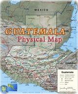

Guatemala Political Map
|
Copyright © Geographic Guide - World in Pictures. American Continent. |
Political Map of Guatemala
